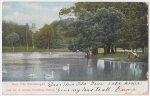
To Miss Ida From Emma

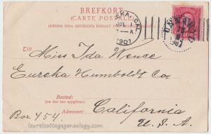
Undivided back, used postcard. Postmarked June 6, 1907 from Unnaryd, Sweden. Stamped in Eureka, California post office on July 1, 1907.

Price:  $10.00

Wow, well this Swedish postcard (the last in our Ida L. Vance Collection unless we come across more) took almost a month to get to Northern California and be delivered to:   “Miss Ida Vance, Eureka Humboldt Co., Box 454. California U.S.A.”

The sender writes:   “Dear Miss Ida your[?] safe home. Give my love to all, Emma.”  Or, is that supposed to be “Dear Miss Ida Vance” ? Hard to tell from the writing. And did Emma return home to Sweden or was Ida her traveling companion who returned early to California, or was Emma’s comment meaning something like, “Here I am traveling all over and you’re safe and cozy at home” ? We could interpret Emma’s short note multiple ways, for sure.

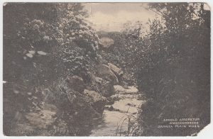
“Motiv från Slottsskogen”  translates as “Scene from the Castle Forest.” Castle Forest is a large park (with lots to do and see) in central Gothenburg (Göteborg) Sweden on 137 hectares (about 338 acres.) It was established in 1874, on land that was once a private reserve for deer hunting.

“Imp. Joh. Ol. Andreens Konströrlag, Göteborg.”

Possibly Johannes Ol. [Olaf, Ole? etc.] Andreens Konströrlag is the publisher and/or printer of this postcard. The abbreviation “imp” is a mystery for the moment.

Source:  Slottsskogen. Göteborgarnas park sedan 1874. http://www5.goteborg.se/prod/parkochnatur/dalis2.nsf/vyPublicerade/8602D7D46CAE30F0C1257A2F003D64CB?OpenDocument. (accessed February 20, 2017).

Arnold Arboretum Rhododendrons

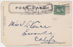
Undivided back, used postcard. Postmarked March 15, 1909 from Fenway Station, Boston, MA. Publisher:  Boston Post-Card Co., 12 Pearl St. No. 770.

“Arnold Arboretum. Rhododendrons. Jamaica Plain, Mass.”

Price:  $5.00

It’s funny, one would not think of this postcard as “hand-colored” as is described on the back, but in looking for color, we do notice the blue-green tinge around the middle of the card. This is one of five that we’ve found that had all been sent to Miss Ida L. Vance of Eureka, CA. In noticing the postcard date, we see that the card was a little old already when it was mailed, since it’s a non-divided back. It was probably produced around 1906 or early 1907 before the postal rules changed. Miss Ida received at least three cards from this particular unknown sender, as we can see the handwriting was the same as in the two (of three) previously posted. (Did postcard collectors mail them to themselves ever? Seems like a good way to record dates and locations, so some probably did!)

A living tree museum on 281 acres and the National Register of Historic Places, just among other things….

Arnold Arboretum: a heavenly place to visit, hang out, and learn. Check out their website, and since we’re especially fond of history, here’s a direct link to their history page.

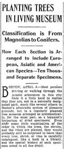
Just to put into context for our postcard era, here are two excerpts from a long article that appeared in the Davenport Daily Republican, (Davenport, IA) April 7, 1901. Reading the second portion gives us a little bit of a time-travel effect:  We’re now in the “future” (beyond, to be precise – over 100 years) that the writer was imagining!

Sources:  The Arnold Arboretum of Harvard University. https://www.arboretum.harvard.edu/ (accessed February 20, 2017).

“Planting Trees In Living Museum.” Davenport Daily Republican. Sunday, April 7, 1901. Sunday. p. 11. (Newspapers.com)

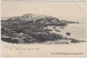
Brace’s Rock, Cape Ann, Mass.

Braces Rock Cape Ann Mass pc1Braces Rock Cape Ann Mass pc2

Initially, four postcards were found that were addressed to Ida L. Vance; since then we ran across a fifth. This is just the third one getting up on the website, and though it was postmarked in May, it reminds me of chilly November weather (in keeping with a fall-going-into-winter theme.) It’s a view in shades of black and grey on a cream-colored background, of Cape Ann with the lighter-colored rock formation being Brace’s Rock.

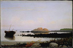
See this Wiki article regarding American artist Fitz Henry Lane (1804 – 1865) for another view:  the artist’s painting, Brace’s Rock, Eastern Point, Gloucester (circa 1864).

Braces Rock Eastern Point Gloucester by Fitz Henry Lane

But from browsing through historical newspapers, what is striking, is the sense of forgotten history, but also of the contrast between today and “yesterday” when the East Coast waters seemed to be full of schooners, steamers, whalers, and newspapers and journals were full of reports on the same. Stepping back a little further in time (just through the fog…)

Storms and wrecks

From a December 1859 article in American Traveler, regarding the wreck of the schooner Prudence Nickerson, who’s crew (or captain or both) mistook another ship’s light for that of (presumably) a lighthouse:  “The light proved to be that of the steamer M. Sanford, lying at anchor between Ten Pound Island and the Point, and was seen over the low land at Brace’s Cove. The Prudence ran a short time when she struck on the eastern end of Brace’s Rock, and went to pieces in about two hours. The captain and crew succeeded in getting on the rock by means of the main bottom, although one of them was nearly washed off in the attempt. They saved nothing but what they had on and remained on the rock till daylight, when they waded ashore.”

From the Shipping News, Vol. VI, Issue 314, an article that had appeared in the Salem Gazette, regarding a violent storm in October of 1792,  “Capt. Samuel Ingersoll, of Beverly, homeward bound from Port-au Prince, ran upon rocks at Brace Cove, and lost all but the people’s lives.”

On a lighter note

Regarding the steamer Reindeer’s pleasure excursion in July of 1865 reported in the Cape Ann Light and Gloucester Telegraph:

“Leaving Fort Wharf at half past twelve, the steamer soon passed around Eastern Point and turned her head to the eastward. To those who had not sailed in that direction before, it was pleasing to note the different points of local interest that had been visited time and again from the land. Brace’s Rock and Cove, Pebble Stone beach, Bass rocks, Little Good Harbor beach, Salt Island, Long beach and Milk Island, each in succession presented a different aspect from what the landsman had been accustomed to observe when visiting those places.”

A sea “monster”

Two offerings from February and January 1870, appearing in the Cape Ann Advertiser:

“The great curiosity found by Mr. Barrett, at Brace’s Cove, is on exhibition at No. 108, Front street. It is pronounced something remarkable, and no one, as yet, can tell what it really is.” 

Further investigation showed the earlier report:

A Great Curiosity. – Mr. Moses Barrett, of East Gloucester, recently found at low water mark, at Brace’s Cove, a most singular object, which resembles the head of some kind of marine monster. It is in form of an owl’s head, with large bony projections which look like ears. Its weight is about seventy-five pounds, and it bears evidence of having been in the water some years. Hundreds have visited it the present week, and all pronounce it a remarkable curiosity.”

Wow – was it a hoax or real? If real, here’s to hoping though that the poor sea creature was given some thought (by many) to being something more than just a curiosity or scientific specimen. (Cecil and Beanie was my favorite cartoon.)

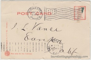
Undivided back, used postcard. Postmarked May 3, 1906 from Gloucester, Massachusetts. Publisher:  The Rotograph Co., New York. Printed in Germany.

Price:  $7.00

Sources:  Fitz Henry Lane. n.d. https://en.wikipedia.org/wiki/Fitz_Henry_Lane. (accessed November 28, 2015).

“Ship News. Disasters &c”. American Traveler. Boston. Saturday, December 17, 1859. (Genealogybank.com)

“Marine Intelligence”. Salem Gazette. Tuesday, October 16, 1792. Shipping News, Vol. VI, Issue 314, p. 3. (Genealogybank.com)

“Isle of Shoals”. Cape Ann Light and Gloucester Telegraph. Saturday, July 22, 1865, p. 2. (Genealogybank.com)

“Off-hand Local Jottings”.  Cape Ann Advertiser. Friday, February 4, 1870, p. 2. (Genealogybank.com)

“A Great Curiosity”. Cape Ann Advertiser. Friday, January 28, 1870, p. 2. (Genealogybank.com)

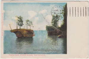
Profile Rock, Apostle Islands, Lake Superior

Profile Rock Apostle Islands Lake Superior pc1Profile Rock Apostle Islands Lake Superior pc2

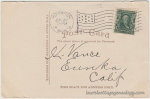
Divided back, used postcard. Outgoing postmark June 29, 1908 from Houghton, Michigan and receiving postmark July 5, 1908 at Eureka, California. Publisher:  E. C. Kropp Co., Milwaukee, Wisconsin. Number 1115.

Price:  $12.00

Another for Ida

This is the second in our small Ida L. Vance Collection, and shows what appears to be a colored image produced from a photo. Note the sailboat on the horizon:  This vessel looks like it was drawn in or maybe it was a faint image that was outlined. In any case, this 1908 postcard shows a view of Profile Rock, situated off the northern shore of Basswood Island in the Apostle Islands of Wisconsin. The profile appears on the right-hand side of the rock. You can see the prominent nose and ridge over the eye. (It looks like he is staring into the water.) Below is a map of the islands courtesy of Google.
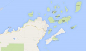
Map of Apostle Islands

A sea stack

The name for this type of rock formation is “sea stack” which is formed by weathering and erosion. Imagine a rock wall that has a cave-like indentation; the waves knocking against the rock on both sides and water seeping in any fissures; the passage of time creating a hole in the rock, gradually getting bigger, creating an arch. At some point, the weight of the arch becomes too great, breaking and falling into the sea, or in this case Great Lake, and voila, you are left with a sea stack.

Old-school for a minute

Discovering ancestral ties to the Michigan and Ontario, Canada, Lake Superior region on Dad’s side some years ago, led to the purchase of a number of books on the Ojibwe people which grace the bookshelf not five feet away (so dramatic, chuckle) from where I sit typing this in our little cottage. Besides naturally wanting to learn about a fascinating culture and history, the books were bought in hopes of finding some mention of our direct ancestor, Chief Na-ges-sis, whose daughter Ikwe-wa-ni-gen-its married Louis Majeau, French-Canadian voyageur for the Northwest Company. Alas, there was no mention of Na-ges-sis found, but it strikes as such a refreshing novelty, for this post research, to be able to refer to a set of books in one’s own living room, just a glance away….Not to say that the internet is not extremely well-appreciated – essential nowadays for research. But the most interesting Apostle Island reference on the shelf was found in Kitchi-Gami, Life Among The Lake Superior Ojibway, an account by German geographer, ethnologist and travel writer, Johann Georg Kohl, when he stayed on Madeline Island (then called La Pointe) for four months in 1855:

From the rank of princes

“La Pointe belongs to a larger group of islands, which the French missionaries named Les Isles des Apôtres. They play a great part in the Indian traditions, and seem to have been from the earliest period the residence of hunting and fishing tribes, probably through their geographical position and the good fishing in the vicinity. The fables of the Indian creator, Menaboju, often allude to these islands, and the chiefs who resided here have always laid claim, even to the present day, to the rank of princes of the Ojibbeways…..The great fur companies, too, which, after them, ruled on Lake Superior, had one of their most important stations at La Pointe; more especially the once so powerful North-West Company, which carried on a lively trade from this spot as far as the Polar Seas.”

Many names for the Rock

From John Lindquist’s excellent webpage, Views of the Apostle Islands, Profile Rock  “…has also been called Lone Rock, Floating Rock, and Honeymoon Rock – the last name being the most commonly applied today.”  (We wonder too, what the native tribes called it.) Lindquist quotes J. M. Turner on the importance of Profile Rock to the Indians,

“It was thought…that when they were encamped on the island in front of the face that no harm could befall them. This belief had such a firm hold upon the Indians of this whole region that when a band of fugitives were hard pressed and likely to fall into the hands of their pursuers they would always fly to the protected camping grounds within the sight of the Great Stone Face well knowing that no enemy would dare to molest them once they were there. “

One last note

Just to clarify regarding the aforementioned Chief Na-ges-sis and daughter, they are thought to have been centered around the Straights of Mackinac area in Michigan (not the Apostles) though Louis Majeau, in his travels with the Northwest Company, must surely have made stops at La Pointe. There was a little confusion in the past about the birthplace of one of the daughters of Louis Majeau and Ikwe-wa-ni-gen-its:  Madeleine Majeau’s marriage record to Henry Campau looks like it may say Madeleine’s birthplace was,  “des Îles du lac Superieur”  from which it was thought that she was born on one of the islands near Mackinac, but if you really scrutinize the original handwriting, and look at the transcribed copy (also in French) you’ll see it actually says,  “des issus du lac Superieur”  meaning from the Lake Superior area. Just mentioning this for anyone researching this line, and in the hopes that some reference may at some point turn up for more on Chief Na-ges-sis. And, of course, this Madeleine was a different woman than the one the Apostle island was named for. Madeline (formerly La Pointe) Island was named after the wife of French-Canadian trader Michel Cadotte, she also being the daughter of Chief White Crane. (John Lindquist’s webpage link above has a photo of the historical plaque regarding the same.

Sources:  Apostle Islands. Google Maps.

Caves, arches, stacks and stumps. GCSE Bitesize. Web accessed August 1, 2015.

Kohl, Johann G., Kitchi-Gami. Life Among The Lake Superior Ojibway. 1860. Trans. Lascelles Wraxall. Saint Paul, MN: Borealis Minnesota Historical Society Press, 1985.

Lindquist, John. Views of the Apostle Islands. Web accessed August 2, 2015.

Turner, J.M. Lake Superior Region. Ashland, WI:  W.E. Prudhomme, 1892.

Moll, Harold W. and Norman G., Lewis and Batteese Mashue, Father and Son, Through Fur and Saginaw Valley Timber. Unpublished collection assembled and bound by Michigan State Library, 1954 – 1958.

Ste. Anne, Detroit, Michigan, U.S.A. (1801-1842) p. 1949-1950. U.S., French Catholic Church Records (Drouin Collection), 1695-1954. (Ancestry.com)

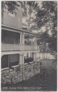
Summer Home, Harbor Point, Michigan

Summer Home Harbor Point Michigan pc1Summer Home Harbor Point Michigan pc2

A small collection…

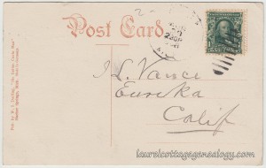
This is the first of five postcards that were all sent to Ida L. Vance, of Eureka, California. According to the Find A Grave website, Ida was born March 17, 1872 in Humboldt County, CA, was married to Fred C. Hauck, and unfortunately (always sad to read these type) died at the young age of 39, on August 14, 1911. She was the daughter of John McGregor Vance and Sarah Jane (Babbitt) Vance, and one of five children. The 1880 Federal Census lists the parents’ place of birth as New Brunswick, Canada, and John’s occupation as Day Laborer. By 1900, John has made some major career advancements, as this census gives his occupation as Railroad President.

Where is Harbor Point?

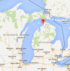
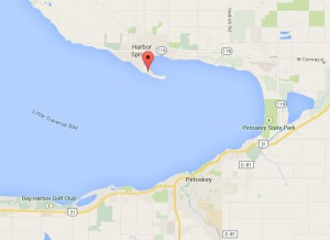
Harbor Point is an unincorporated community and peninsula in Northern Michigan, southwest of the Straits of Mackinac. The peninsula is located in the Little Traverse Bay of Lake Michigan, jutting off south from the town of Harbor Springs, and across the Bay from the town of Petoskey. Per Wikipedia, Harbor Point began as a resort in 1878, and was originally called Lansing Resort. We wonder whether the summer home shown here is still standing and in use. (Hoping so!)

Michigan MapHarbor Point Map

Divided back, used Real Photo Postcard. Postmarked September 5, 1908. Publisher:  W. S. Darling, “the Indian Curio Man.” Harbor Springs, Mich. Number 68. Made in Germany.

Price:  $20.00

Sources:  Find A Grave Memorial# 84383715. Find A Grave. Web accessed May 3, 2015.

Year: 1880; Census Place: Eureka, Humboldt, California; Roll: 66; Family History Film: 1254066; Page: 362D; Enumeration District: 032; Image: 0026. (Ancestry.com)

Year: 1900; Census Place: Eureka Ward 4, Humboldt, California; Roll: 86; Page: 13A; Enumeration District: 0025; FHL microfilm: 1240086. (Ancestry.com)

Maps of Michigan showing Harbor Point, Location. Google.com.

West Traverse Township. n.d. http://en.wikipedia.org/wiki/West_Traverse_Township,_Michigan (accessed May 3, 2015).